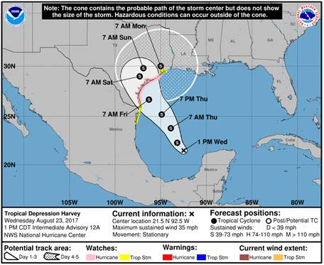
As many of you are aware, the remains of Harvey have been updated to Tropical Depression Harvey. Based on the latest forecast from the National Hurricane Center, TD Harvey could redevelop into a tropical storm later today with potentially hitting landfall on Friday.
Based on the models, Harvey could deliver a significant amount of rainfall to the Texas Coast. The forecast shows that the lower Brazos River watershed, including Fort Bend County, could see between 7 to 12 inches of rainfall with isolated areas of over 20 inches. The true impacts on the Sugar Land area will depend on the speed and duration the storm as it moves through the area. With the high potential, the District and their consultants are keeping a close eye on this storm and stand ready to respond as needed. At this moment, the internal drainage system is at or slightly below its normal levels with the main outfall channel open and clear. This means that 100% of the District’s flood storage capacity is available in the event we do see a significant amount of rainfall. The District’s pumps and generator are also ready to be operated if needed.
Please note that at this time, there is no immediate threat to the District and its residents; however, this storm is not something to ignore. Although it might only be a tropical storm, a quick look back in history shows that tropical systems in weak steering pattern have produced devastating rainfall amounts before: – TS Allison: 28.5 inches in 12 hrs (NE Harris County) – TS Claudette: 43.0 inches in 24 hrs (Alvin, TX) – TS Amelia (1978): 50.0 inches (72 hrs) over Medina and Kerr Counties – Unnamed (1921): 36.40 inches (18 hrs) Thrall, TX
As residents, please take a moment to review your own personal emergency response kits for your homes. Regardless of its impacts, this storm is a good reminder on how we need to always stand ready during hurricane season. For more information on Hurricane Preparedness, please visit the Fort Bend County Office of Emergency Manager at http://fbcoem.org/hurricanes/ or the National Hurricane Center at http://www.nhc.noaa.gov/prepare/ready.php.
As always, feel free to contact the District if you have any questions or concerns.